


In 2014, Carapella posted links in many places, including the Native American and American Indian Issues group on Facebook. It immediately drew a great deal of conversation. Many people looked at the maps and found problems. Carapella was resistant to their comments. Some are speakers of their own languages and told him he'd made errors in how he represented their specific nations, but he told them that he knew the right names, and that they were wrong. That discussion is gone. (If you're on Facebook, you know that you can delete one of your posts and the entire thread of comments will be deleted, too.)
This is what Carapella said when he launched his project in 2014:
This map presents every documented, known Native American tribe that was here in pre-contact time, before the arrival of Europeans. All of the tribal nations documented here are in their original locations before the European Invasion affected their movement and displacement. Most of the names of tribes are in their own language, and are not the names given to them either by the invading Europeans or even other tribes. For example, we correctly use the name Numinu for what most Americans would call the Comanche Nation. The Sioux are referred to here in their own language as the Lakota. Unfortunately, many of the tribes here are indeed listed by their given name. Their original names were lost in the War against the Indians which left many tribes numberless, or forced remnant bands to amalgamate into larger, stronger tribes. We seek here to honor those hundreds of tribal nations who existed in their respective territories for millennia unscathed until the encroachment of Europeans. This is a tribute to all of those forgotten tribes whose names had been lost to the wind, but who live in the hearts and minds of modern-day Native Americans who managed to survive the largest full-scale holocaust in Man's history. We also honor the Indigenous Nations of this land by giving them ownership of their own names for themselves.
That paragraph has since been revised. Currently on his website, Carapella states:
Here you will find the most comprehensive maps of pre-contact and at-contact Native North America to date. These maps use Tribal Nation’s original indigenous names for themselves, and show where Tribes were just before contact with outsiders . The intent of these maps is to instill pride in Native peoples and to be used as teaching tools from a Native perspective. These maps are part of my Tribal Nations Map series-which cover the Nations indigenous to the “United States,”, “Canada”, "Mexico" , "Central America", "South America" and “Alaska." Your purchase supports multiple upcoming maps. I credit the many hundreds of Cultural directors, elders, educators and linguists that have helped me centralize these names onto one visual display.
In my review in 2014, I focused on the Pueblo Indian Nations portion of the map. I'm doing that again, because that portion of the map, like the description of the project, has been revised. This review is arranged based on what Carapella said the maps would do.
Carapella said that his map would show Native Nations and where they were located pre-contact with Europeans. Sounds good, right? But--I'm asking you to look and think critically about that goal. Right now there are over 200 federally recognized nations in the US (not counting Alaska). There were a lot more, pre-contact. How, I wondered, was Carapella going to show the locations of those 200+ federally recognized nations in the hundreds and thousands of years prior to contact, or "at contact"? We didn't all come into contact with Europeans at the same time.
Let's hone in on an example.
The place my nation (Nambé O-Ween-Gé) is at right now is where we've been since the early part of the 14th century. If you go back further in time, we were somewhere else. I'm talking about places like Bandelier, Mesa Verde, Chaco Canyon... (you might know those places as where the "Anasazi" people lived, but they are now--correctly--identified as ancestral homes of today's Pueblo Indians). On his map, Carapella chose to show us at our current locations, which is fine, but that decision points to a difficulty in the framework for the project. How do you convey thousands of nations in thousands of locations over thousands of years on a single map? How do you tell students which point in time a location on a map represents? That isn't unimportant data. It is vitally important.
Second, Carapella said that his maps would include nations that he called "numberless" which, he tells us, means ones that no longer exist. How, I wondered in 2014, would his map distinguish between those "numberless" ones and those that are currently recognized as sovereign nations?
As a Pueblo Indian woman enrolled at Nambe, I know there are nineteen sovereign Pueblo Indian nations in New Mexico right now. There were more, pre-contact. I know the names of some of them. I think it is important to know about them, but it is also important to know they aren't among the nineteen sovereign nations who have nation-to-nation negotiations--today--with the US government. Children in New Mexico should know the names of the nineteen Pueblo Indian nations, and all children should learn about us as we are, today, rather than the tragic and romantic content they learn that confines us to the past. This map shows the nineteen Pueblo Indian nations of New Mexico:

When I reviewed the Pueblo portion of his map in 2014, Carapella read my review and wrote to me to say he'd revise it. Last year, he sent me a screen capture of revisions he'd made. He asked me to update my review, but the revisions are just as bad as the original, so, I didn't revisit my older review.
Here's the screen cap he sent me. It has way more than nineteen. The first map didn't have all of those on there. That makes this one "more comprehensive" but also more confusing!
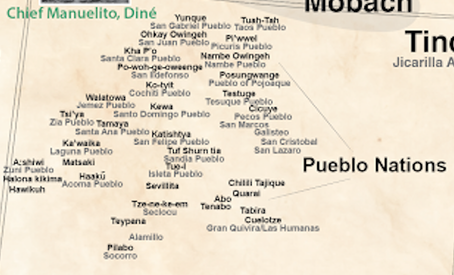
Here, I have inserted arrows to show you the "numberless" ones that aren't part of the nineteen:

In some instances, Carapella has made a different kind of error. He correctly lists A:shiwi (Zuni) but beside it he also lists Matsaki, Hawiku, and Halona, but they're villages that are part of A:shiwi. In my earlier review, I wrote that my own village ought to be listed as Nambé O-Ween-Gé, and pointed him to our tribal seal. But as you see above, he chose to use "Nambe Owingeh" instead.
Third, Carapella said his map would provide the names the nations used for themselves, rather than the ones outsiders used for them. That, too, is ambitious for many reasons. How did he find out those names? He tells us he made phone calls and visited people, but he doesn't name any names. His credit is a blanket one which tells us nothing. Because of our nation-to-nation relationship with the U.S. government, you can find a list of the 567 nations, which includes, superceded names (in parenthesis). It would be interesting for librarians/teachers to download that pdf and do some comparisons. How do the nations request they be listed? Does that match with what Carapella did?
As critical users of information, one of the things we do--and teach students to do--is to ask about the sources for information we're given. Carapella doesn't name his sources for the map, but he provides a "Resource List of Books/Movies/Websites" that he recommends. It, however, has The Education of Little Tree on it. That's a huge problem! That book has been soundly discredited for its content and because its author was faking an identity ("Forrest Carter" is actually Asa Carter--speechwriter for George Wallace--and a member of the KKK, too).
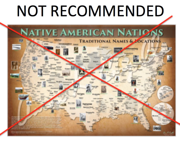
In short? The revisions to Aaron Carapella's Tribal Nations map of North America are not an improvement. The map is still flawed and, as such, I do not recommend it.
0 Comments on A second look at Carapella's TRIBAL NATIONS MAPS as of 1/1/1900
Add a Comment