new posts in all blogs
Viewing: Blog Posts Tagged with: Maps, Most Recent at Top [Help]
Results 26 - 50 of 143
How to use this Page
You are viewing the most recent posts tagged with the words: Maps in the JacketFlap blog reader. What is a tag? Think of a tag as a keyword or category label. Tags can both help you find posts on JacketFlap.com as well as provide an easy way for you to "remember" and classify posts for later recall. Try adding a tag yourself by clicking "Add a tag" below a post's header. Scroll down through the list of Recent Posts in the left column and click on a post title that sounds interesting. You can view all posts from a specific blog by clicking the Blog name in the right column, or you can click a 'More Posts from this Blog' link in any individual post.

By: Miranda Dobson,
on 5/26/2015
Blog:
OUPblog
(
Login to Add to MyJacketFlap)
JacketFlap tags:
Capital Markets,
Alibaba Group,
biggest ipos,
capital markets journal,
capital markets law,
initial public offering,
ipo,
ipo law,
Jeffrey Golden,
Lachlan Burn,
Mitu Gulati,
worlds biggest ipos,
Law,
Journals,
Maps,
nasdaq,
*Featured,
oxford journals,
Add a tag
In 2014, the Chinese corporation Alibaba Group famously released the world's biggest US-listed IPO. IPO stands for 'initial public offering' and represents the first sale of stock by a company to the public. There have been many instances of record-breaking IPOs from around the world - and as far back in history as 1602 - that also deserve our attention. Click on our interactive map below to find out about the biggest IPOs from across the globe.
The post The biggest IPOs from across the globe appeared first on OUPblog.
Here's a new black & white map for a middle-grade novel coming out soon. I'll post the book when I get a copy. (I've been humming that Dora the Explorer song A LOT lately...
I'm the map, I'm the map, I'm the map, I'm the map...)
By: Ellie Gregory,
on 4/20/2015
Blog:
OUPblog
(
Login to Add to MyJacketFlap)
JacketFlap tags:
Politics,
Maps,
map,
British politics,
david cameron,
*Featured,
who's who,
ed miliband,
British Parliament,
Online products,
UK General Election 2015,
British politicians,
general election 2015,
Add a tag
In anticipation of the imminent General Election on 7 May 2015, we pulled together information from Who’s Who to take a closer look at the major players bidding for our votes. We’ve mapped nine party leaders and deputy leaders to their constituencies.
The post Mapping out the General Election appeared first on OUPblog.
By: AlyssaB,
on 2/6/2015
Blog:
OUPblog
(
Login to Add to MyJacketFlap)
JacketFlap tags:
Books,
Religion,
Politics,
Maps,
map,
*Featured,
Ani Sarkissian,
authoritarian government,
mapbox,
nondemocratic rule,
religious repression,
The Varieties of Religious Repression,
Why Governments Restrict Religion,
Add a tag
Religious repression—the nonviolent suppression of civil and political rights associated with religion—is a growing and global phenomenon. Though it is most often practiced in authoritarian countries, it nevertheless varies greatly across nondemocratic regimes. In my work, I’ve collected data from more than 100 nondemocratic states to explore the varieties of repression that they impose on religious expression, association, and political activities, describing the obstacles these actions present for democratization, pluralism, and the development of an independent civil society.
The nondemocratic countries of the world can be divided into four categories based on the number of religious groups they target with religious repression (All, All But One, Some, and None). Knowing how many and which groups states target helps us to understand how rulers in countries with different levels of political competition and religious divisions use regulations on religion to repress, co-opt, and prevent potential political opposition from challenging their rule.
The color-coded map below shows the degree to which nondemocratic countries repress religions. Click on the larger markers with a symbol for more detail on that particular country.
Featured image credit: Photo by Saint-Petersburg Orthodox Theological Academy. CC BY-ND 2.0 via Flickr.
The post Using religious repression to preserve nondemocratic rule appeared first on OUPblog.

Our theme for January is Landscape so here you go. These are from
This Land Is Your Land, a picture book about land forms. It's by Catherine Ciocchi, published by
Arbordale Publishing and illustrated by me, Cathy Morrison. You can see more about this and other projects on my
Studio With A View Blog.
Happy New Year and thanks so much for taking a look!
By: Molly Grote,
on 12/11/2014
Blog:
OUPblog
(
Login to Add to MyJacketFlap)
JacketFlap tags:
Day of Goodwill,
Saint Lucia's Day,
Christmas,
Geography,
Maps,
Festivus,
Hanukkah,
scotland,
holiday traditions,
Sinterklaas,
Atlas of the World,
*Featured,
St. Nicholas Day,
Images & Slideshows,
thinglink,
Add a tag
Here at Oxford University Press, we’re getting ready for the holiday season, and we were inspired by the new, twenty-first edition of the Atlas of the World to explore holiday traditions from around the world, including our 2014 Place of the Year, Scotland. Take a look at the map below to learn and see a little bit about the food, decorations, and other traditions of holiday celebrations taking place around the world at this time of year.

Image credit: Christmas lights on the tree in front of the Capitol Building, Washington, DC by Jonathan McIntosh. CC-BY-2.0 via Wikimedia Commons.
The post Holiday traditions from around the world appeared first on OUPblog.

By: Samantha Zimbler,
on 12/10/2014
Blog:
OUPblog
(
Login to Add to MyJacketFlap)
JacketFlap tags:
Law,
Maps,
human rights,
*Featured,
international law,
Online products,
OPIL,
oxford public international law,
Oxford Reports on International Law,
case map,
human rights awareness day,
human rights awareness month,
ORIL,
World Human Rights Day,
Add a tag
To mark Human Rights Day, we have produced a map of 50 landmark human rights cases, each with a brief description and a link to a free article or report on the case.
The cases were chosen in conjunction with the editors of the Oxford Reports on International Law. These choices were intended to showcase the variety of international, regional, and national mechanisms and fora for adjudicating human rights claims, and the range of rights that have been recognized.
The following map provides a quick tour to these cases, highlighting trends and themes, some positive, some negative.
Major Historical Events
A lot of these cases are important because of the way they demonstrate the possibility of righting historic injustices: for the disappeared of Honduras, for victims of Argentina’s “dirty war,” for Hitler’s slaves, heroes of the Chernobyl disaster, and East Germans gunned down trying to reach the West. They also shine a light on what happens in the aftermath of war: Peruvian politicians attempting to pass amnesty laws to prevent accountability, people on the losing side of World War II having their property stolen, and the operation of post-World War I minorities treaties.
Africa
From a human rights standpoint we probably have a number of preconceptions about Africa – large scale atrocities and impunity. While that is horribly true in places there are also aspects of the cases highlighted in our map that might surprise some. The one case about an investor’s rights (Diallo) features an African state, not one of the typical capital exporting states, taking legal action on behalf of its citizen. There is also the range of fora in Africa that offer remedies. In addition to the obvious forum – the Commission and Court of the African regional human rights system, we have cases from the East-African Court of Justice and the ECOWAS Community Court both finding that they are empowered to adjudicate on human rights issues as universal as the rights of indigenous peoples and anti-slavery. Whereas you wouldn’t be surprised to see a post-Apartheid decision from the South African domestic courts in this list, it is instructive to see a case from Ugandan domestic courts on press freedom.
Expansion of Rights
The modern proliferation of rights is often a topic of humorous exaggeration. These cases exemplify a great breadth of rights beyond the classic civil and political rights of freedom from torture, or free speech. Where it does address these topics there is a novel twist: on torture, whether it is OK to extradite criminals to a place where they face torture; on free speech, whether Holocaust denial should be protected. Several have gender aspects: states’ obligations to prevent domestic violence, women being required to prove they are the “breadwinner” in order to have access to unemployment benefits, sexual violence against women as a means to silence political dissent. Others bring in group rights: self-determination, rights of indigenous peoples, and even the rights of tribes imported via the slave trade. Add to these cases on the execution of minors, anti-homosexuality laws, and treating a person’s DNA as their private matter, and we see how far the law has developed.
Unattractive Victims
Opponents of human rights litigation often point out that these rights are frequently claimed by people whom we deplore. It is true that many of the people making claims in these cases were accused of murder and terrorism, or at least were sworn enemies of the state that (allegedly) abused them. So the lesson here is that these are human rights, not “nice people’s” rights.
Human Rights as an Excuse
With so many human rights remedies available there is a temptation for litigants, whether states or individuals, to use human rights as a way to get an issue before a court. You would expect the case between Georgia and the Russian Federation at the International Court of Justice (ICJ) to be about the illegal use of force by Russia. Instead, Georgia sued under a human rights treaty: the International Convention on the Elimination of All Forms of Racial Discrimination (CERD). Why? Ordinarily Russia could refuse to submit to a legal procedure at the ICJ, but the CERD contains a provision saying that in any dispute under that treaty between two states that have ratified it (which Russia and Georgia had) both parties must agree to the jurisdiction of the ICJ. So Georgia gets minor revenge for Russia’s invasion and annexation by suing Russia for racial discrimination.
Misleading Maps
You might think the clustering of pins in our map is about abuses, but actually it demonstrates access to a legal process (and, depending on implementation) a remedy. So plenty of pins in Europe, and Israel, but none in Saudi Arabia or North Korea.
These 50 cases are by no measurable sense the 50 greatest or most important cases, but they do amply demonstrate the expansion and increasing profile of this, mostly admirable, element of the rule of law.
Featured image credit: Roosevelt’s “Four Freedoms”. Photo by dbking. CC-BY-SA-2.0 via Wikimedia Commons
The post Human Rights Awareness Month case map appeared first on OUPblog.

By: Barney Cox,
on 12/4/2014
Blog:
OUPblog
(
Login to Add to MyJacketFlap)
JacketFlap tags:
Books,
Politics,
political science,
Maps,
map,
African Union Mission to Somalia,
international relations,
nuclear disarmament,
Social Sciences,
*Featured,
Iran nuclear crisis,
nuclear missiles,
foreign relations,
united nations security council,
Online products,
Syrian civil war,
disarmament,
global peace index,
military expenditure,
SIPRI Yearbook Online,
UN arms trade treaty,
Add a tag
The world today is a very complex place. Events such as the Afghanistan and Iraq wars, the devastating conflict erupting in Syria, and the often-fraught relations between the world’s superpowers highlight an intricate and interconnecting web of international relations and national interests. The SIPRI Yearbook, published every year, keeps track of these global developments around issues of security, and analyses the data and implications behind the headlines you’ve been reading in the past year – from conflicts and armaments to peace negotiations and treaties.
Did you know, for example, that in 2013, the Arms Trade Treaty was opened for signature in the UN HQ in New York City? This treaty, when it comes into force, will roll out international arms regulation for trading in arms, and prohibit the sale of any arms by a state party which will be used in genocide or crimes against humanity. Or that throughout 2013 the Democratic Republic of Congo, combined with international assistance, made considerable gains in stabilizing troubled regions of the country, bringing the state one step closer to security and safety?
With snippets taken from the SIPRI Yearbook 2014, which analyses significant events across the globe in the previous year, the map below helps you explore the global state of affairs, as they happened in 2013:
Headline image credit: Two destroyed tanks in front of a mosque in Azaz, Syria after the 2012 Battle of Azaz. Photo by Christian Triebert. CC BY 2.0 via Wikimedia Commons
The post Charting events in international security in 2013 appeared first on OUPblog.

.jpeg?picon=3306)
By: Zoe,
on 11/12/2014
Blog:
Playing by the book
(
Login to Add to MyJacketFlap)
JacketFlap tags:
Storytelling,
Adventure,
Mermaids,
Gardening,
Maps,
Families,
Grandparents,
Kindness,
Boats,
Camping,
Islands,
Beaches,
Mairi Hedderwick,
Being independent,
Post/mail/letters,
Inclusive/diverse books,
Add a tag
Over the last couple of year’s I’ve read quite a lot about how children’s books with a very specific cultural setting are not favoured by publishers because it is hard to sell rights widely; publishers are keen for “universal” stories which translate (literally and figuratively) well across borders and languages.
Whilst I understand publishers’ drive to maximise sales, I think a great deal is lost if we ignore stories boldly and vividly set in specific and identifiable locations and cultures. Indeed, considering the current drive for increasing diversity in children’s books, I would argue that books which are culture specific have a vital role to play.
And of course, a great book will be “universal” whether or not it is set in a specific time, location or country; enduring stories speak to that which we share whatever our differences.
I have been a fan of Mairi Hedderwick’s books for as long as I can remember. She writes and illustrates rural Scottish island life in a magical way. She captures truths like poetry can in her watercolours of Hebridean life, whilst her stories are full of acute observations about family life that’s more or less the same wherever you are in the world, exploring issues such as sibling rivalry and intergenerational relationships.
 The Katie Morag Treasury by Mairi Hedderwick is a glorious book, bringing together a mix of the most popular previously published Katie Morag books and new stories and illustrations first heard and seen on episodes of the highly acclaimed BBC Katie Morag TV show. It really is a treasury, with a range of witty and poignant stories, illustrated in ink and watercolour in a way that invisibly and movingly marries romance and realism.
For kids listening to these stories Katie Morag’s tales act as mirrors; yes she may live in a community vastly unlike the one the young reader or listener lives in, but that only makes it more interesting and reassuring to read that Katie Morag has the same sort of worries, plays the same sorts of games and quarrels with her parents just like they do. Thoughtfulness is a consistent thread in all these stories, and Katie Morag herself is a terrific role model; full of strength and imagination she is not afraid to explore, to try new things, or to be kind.

This is a keeper of a book, one which works well both as a read-aloud, or for children who can read themselves. Indeed the lovely hardback binding makes this ideal for older readers who might not want to be seen reading picture books any more.
Last year when we were holiday in Scotland we collected a stash of shells and sea glass and re-reading these fabulous Katie Morag stories inspired us to get our jars of them out of our natural history museum, and play with them using a home-made light box.

I borrowed one of our large plastic boxes which we normally store lego in, lined it with white tissue paper, and then put a load of fairy lights inside it. With the fairy lights turned on, and all the other lights turned off and curtains drawn we entered something of a soothing world where the girls could then make patterns with the shells and sea glass, with soft light shining through.

If you don’t have any sea glass, you could do this activity with florists’ glass (vase) pebbles instead, making light imbued mosaics.

Music which goes really well with Katie Morag stories (though maybe not with the light box activity as much of it will get you up and dancing) includes:
My favourite radio programme – available worldwide online – Travelling Folk. This is BBC Radio Scotland’s flagship folk programme and it’s full of treats each week.
Arrangements of songs like you’ve never heard before from Billy McIntyre and his All Star Ceilidh Band, who I’d love to hear live because they are just WAY out there…. Pop! goes the Ceilidh is a hysterical album with covers of lots of pop classics (eg Living on a Prayer, Robbie William’s Angels, Billy Idol’s White Wedding) redone with fiddle, accordion and more. It will put a crazy smile on your face.
Anything by Skippinish but especially Land below the Waves that always gives me goosebumps:
Other activities which you could try out alongside reading The Katie Morag Treasury include:
Creating a sand imprint roller (!) like we did when I reviewed audiobook versions of the Katie Morag stories.
Making stone soup, as per one of the six folk tales told at Grannie Island’s Ceilidh, and reproduced in The Katie Morag Treasury. If you’ve never made stone soup here’s a recipe to get you started.
Adapting a pair of shoes to make your own tap shoes; Katie Morag learns to tap dance but uses her wellies and a little bit of ingenuity. Here are some ways you can turn your regular shoes into tap shoes.
What are your favourite children’s books which have a very strong sense of location?
Disclosure: I was sent a free review copy of The Katie Morag Treasury by the publisher
By: Samantha Zimbler,
on 11/11/2014
Blog:
OUPblog
(
Login to Add to MyJacketFlap)
JacketFlap tags:
History,
World,
Maps,
remembrance day,
world war I,
WW1,
Veterans Day,
armistice day,
first world war,
*Featured,
Online products,
Oxford Bibliographies,
Add a tag
Today is Armistice Day, which commemorates the ceasefire between the Allies and Germany on the Western Front during the First World War. Though battle continued on other fronts after the armistice was signed “on the eleventh hour of the eleventh day of the eleventh month” of 1918, we remember 11 November as the official end of “the war to end all wars.”
In honor of the Great War, the Oxford Bibliographies team has created this interactive map, a visual bibliography of critical moments, battles, people, technology, and other elements that defined the spirit of the times across continents. Explore the trenches, navigate the front-lines, and track troop movements while gaining scholarly insights into this crucial period, from the outbreak of the War to its conclusion and lasting effects.
Note: This map may not be a completely accurate geographical portrayal, but it is intended to depict historical facts pertaining to the “Great War” and the countries and regions involved.
Featured image credit: Battle of Broodseynde [sic] Ridge. Troops moving up at eventide. Men of a Yorkshire regiment on the march. Ernest Brooks. Public domain via Wikimedia Commons.
The post Armistice Day: an interactive bibliography appeared first on OUPblog.

By: Julia Callaway,
on 11/4/2014
Blog:
OUPblog
(
Login to Add to MyJacketFlap)
JacketFlap tags:
midterm elections,
*Featured,
oxford journals,
Lewis L. Gould,
Sociology of Religion,
Grand Old Party,
historic elections,
Journal of American History,
Journal of Church and State,
The Republicans,
Books,
History,
Politics,
elections,
Maps,
America,
election day,
Add a tag
Today is Election Day in the United States, and we’ve mapped out some of the stories behind historic American elections. Explore America’s presidential and Congressional history, from Abraham Lincoln’s first Senatorial race in 1858 to George W. Bush’s hotly-contested victory against Al Gore in 2000. We sourced our facts and figures from The Republicans: A History of the Grand Old Party by Lewis L. Gould and articles from the Journal of American History, Sociology of Religion, and the Journal of Church and State. Some of the contests featured here are widely known, others less so, but all of the locations on our map offer a piece of electoral history.
Heading image: The County Elections by George Caleb Bingham. Public domain via Wikimedia Commons.
The post Mapping historic US elections appeared first on OUPblog.

By: Molly Grote,
on 11/3/2014
Blog:
OUPblog
(
Login to Add to MyJacketFlap)
JacketFlap tags:
Books,
Geography,
maps,
Brazil,
atlas,
scotland,
Place of the Year,
Oxford Atlas of the World,
Gaza,
Ukraine,
Social Sciences,
*Featured,
Ferguson,
Quizzes & Polls,
Place of the Year 2014,
POTY 2014,
POTY2014,
Add a tag
Thanks to everyone who voted over the few weeks as we considered our 2014 Place of the Year longlist. Now that the votes are in, we’ve narrowed the nominees down to a shortlist of five, and we’d love your thoughts on those as well. You can cast your vote using the buttons and read a bit about each place and why they made the list below.
The Place of the Year 2014 shortlist
Scotland
- The highest peak in the United Kingdom is Ben Nevis, which is located in Scotland and measures 4,409 feet or 1,344 meters.
- The Scottish referendum, held in September 2014, drew a staggeringly high percentage of the population and resulted in Scotland remaining part of the United Kingdom.
Ukraine
- Ukraine is the second largest country in Europe.
- Crimea, a peninsula in the south of Ukraine, was universally recognized as part of Ukraine until a referendum held in March 2014 resulted in Crimea voting to unite with Russia, a union that is not universally recognized and has caused controversy in Ukraine and the rest of the world.
Brazil
- Brazil is the world’s fifth largest country.
- Brazil was the host of the 2014 FIFA World Cup, and the 2016 Summer Olympics will be held in Rio de Janeiro.
Ferguson, Missouri
- Ferguson is part of St. Louis County in Missouri, about twelve miles away from the county’s namesake city.
- The shooting of 18-year-old Michael Brown by a police officer in Ferguson, and the protests that followed, sparked a worldwide conversation about race relations in summer 2014.
Gaza
- The Palestinian Authority was given control of the Gaza Strip by former Israeli prime minister Ariel Sharon in 2001.
- Gaza has been the site of a great many disputes between Israel and Hamas. Most recently, the region saw fifty days of violence stretch through July and August of 2014.
Keep following along with #POTY2014 until our announcement on 1 December to see which location will join previous winners.
Image credit: Old, historical map of the world by Guiljelmo Blaeuw. Public domain via Wikimedia Commons.
The post Announcing the Place of the Year 2014 shortlist: Vote for your pick appeared first on OUPblog.

Move over, Frindle. A new classic has arrived!
 Below is my review of The Map Trap by Andrew Clements, as it appeared in the October, 2014, edition of School Library Journal.
CLEMENTS, Andrew. The Map Trap. 2 CDs. 2:29 hrs. S. & S. Audio. 2014. $14.99. ISBN 9781442357013. digital download.
Gr 3-6 -- Alton Ziegler is crazy about maps. He particularly loves the way they can visually display any manner of information in a variety of ways. Surreptitiously, he collects data and creates humorous maps detailing such trivia as the popularity of lunchroom tables (depicted as a topographical map of the cafeteria) or a weather map of a teacher's clothes. Striped tie today? Look out -- the probability of a pop quiz is high. He never meant for anyone to see his collection, but when it's "mapnapped," there's no telling where the road might lead. Keith Nobbs is perfectly cast as the narrator. He creates a pensive Alton that fits the mood of the story. Clements's (In Harm's Way) use of subjective third-person narration is interesting in that the listener is privy to the inner concerns not only of Alton but of his teacher Miss Wheeling as well. Rarely is a teacher's perspective presented with such honesty and clarity in a middle grade novel. Though Nobbs's voice sometimes cracks when portraying female characters, his delivery, nonetheless, is still pleasing and believable. The Map Trap is a thoughtful, holistic look at the middle school environment that will have wide appeal.
Copyright © 2014 Library Journals, LLC, a wholly owned subsidiary of Media Source, Inc.
Reprinted with permission.
The publisher's website contains an audio and a printed excerpt from The Map Trap, as well as a video with author, Andrew Clements.
By: AlyssaB,
on 8/25/2014
Blog:
OUPblog
(
Login to Add to MyJacketFlap)
JacketFlap tags:
Books,
History,
Religion,
american history,
America,
cartography,
Humanities,
*Featured,
maps,
hell,
slideshow,
religion in america,
Damned Nation,
Hell in America from the Revolution to Reconstruction,
Kathryn Gin Lum,
purgatory,
Add a tag
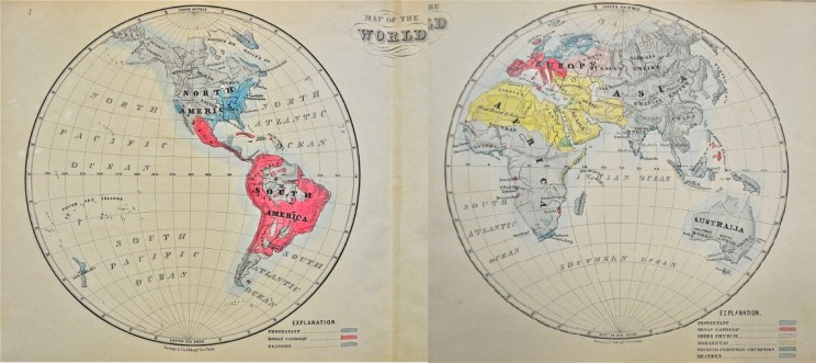
Antebellum Americans were enamored of maps. In addition to mapping the United States’ land hunger, they also plotted weather patterns, epidemics, the spread of slavery, and events from the nation’s past.
And the afterlife.
Imaginative maps to heaven and hell form a peculiar subset of antebellum cartography, as Americans surveyed not only the things they could see but also the things unseen. Inspired by the biblical injunction to “Enter ye in at the strait gate: for wide is the gate, and broad is the way, that leadeth to destruction… and narrow is the way, which leadeth unto life, and few there be that find it” (Matthew 7:13-14 KJV), the maps provided striking graphics connecting beliefs and behavior in this life to the next.
-
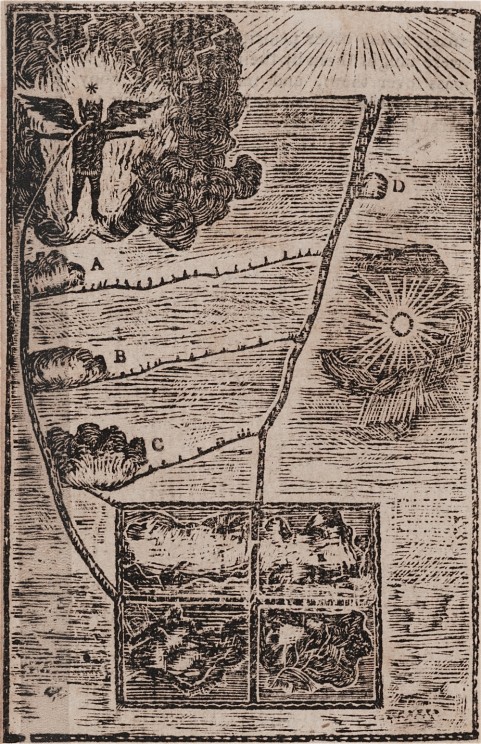
“Mah-tan’-tooh, or the Devil, standing in a flame of fire, with open arms to receive the wicked.”
As early as the 17th century, Catholic missionaries were using didactic visuals of heaven and hell to surmount a language barrier with indigenous North Americans. Such illustrations probably influenced the cosmological map of Neolin, the Delaware Prophet. Born around 1762 near Lake Erie, Neolin experienced a series of otherworldly visions that he turned into a map for his followers. The image here, copied by a white observer, was published some years later in a volume of captivity narratives. The rectangle at the bottom of the map represented the earth and its inhabitants. Those who avoided temptation would proceed directly to future bliss on the path labeled “D,” while those who followed paths A, B, and C would undergo various purgation processes before receiving their reward. The wicked, on the bottom left of the rectangle, would go straight to a fiery hell guarded by the Devil. Neolin warned his followers that the vices Europeans brought, like alcohol consumption, had made the path to future bliss more perilous.
Credit: In Archibald Loudon, A selection, of some of the most interesting narratives, of outrages, committed by the Indians, in their wars, with the white people… (Carlisle [Pa.]: From the press of A. Loudon (Whitehall), 1808-1811). Monroe Wakeman and Holman Loan Collection of the Pequot Library Association, on deposit in the Beinecke Rare Book and Manuscript Library, Pequot L92. Courtesy of the Beinecke Rare Book and Manuscript Library.
-
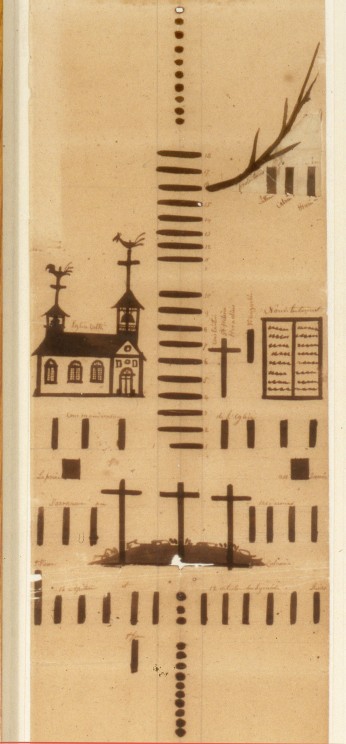
Catholic Ladder
Like earlier didactic devices, this Catholic Ladder (ca. 1840) was created by a French Catholic missionary for the purpose of evangelization. First carved into a large wooden stick, and then painted on a paper scroll measuring nearly five feet long, the Catholic Ladder served as a visual aid for Father Francis Norbert Blanchet and his associates to explain sacred history to the indigenous people of the Pacific Northwest. Blanchet drew bars to represent the passage of centuries and dots to represent years in the life of Christ, and added simple pictures to illustrate sacred events. There is no sign of heaven or hell in this ladder, which simply ends with Blanchet’s mission in the present day. But this wasn’t just a neutral timeline: for Blanchet, there clearly is a wrong path to follow. In the detail shown here, Blanchet depicted the Protestant Reformation as a spindly branch off the main course of sacred history, with the three bars below it representing Luther, Calvin, and Henry VIII.
Credit: By Fr. Francis Norbert Blanchet, ca. 1840. 6 1/2 x 58 in. Section from middle of ladder, showing the Crucifixion to the Protestant Reformation. Courtesy of The Oregon Historical Society, Image Number OrHi 89315.
-
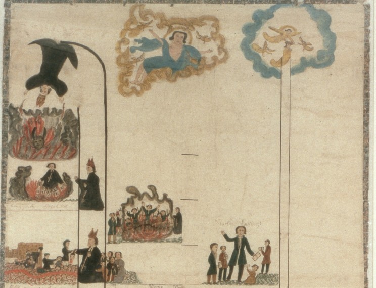
Protestant Ladder
Protestant missionaries Henry and Eliza Spalding, who also traveled to the Pacific Northwest, responded to the Catholic depiction of Reformation heroes with a ladder of their own. Six feet long and two feet wide, the ladder made explicit the biblical teaching about the wide and narrow paths. Painted by Eliza with ink and colored dyes made from berries and natural pigments, the ladder, like Blanchet’s, also illustrated sacred history beginning with Adam and Eve. But it divided this history into the good and the bad, and instead of ending in the present, it ended with the reward of the righteous and the punishment of the wicked. On the right (directionally and morally) path to heaven, the Spaldings included Moses, Paul, and Martin Luther. On the left and wider path to hell, they featured the Tower of Babel, the beheading of John the Baptist, and several scenes with the Pope, culminating with his headfirst fall into a fiery hell where a horned devil awaits.
Credit: By Henry H. and Eliza Spalding, ca. 1845. Section from top of ladder. Courtesy of The Oregon Historical Society, Image Number OrHi 87847.
-
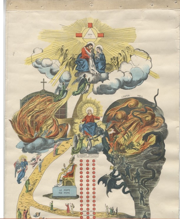
Tableau-catéchisme/Pictorial catechism
If the colorful and dramatic Protestant Ladder was more visually exciting than Blanchet’s monochrome series of bars and dots, Albert Lacombe’s mass-produced version from the 1870s was even more so. Lithography techniques had improved by this time, making it possible to make tens of thousands of copies of the striking six foot by one foot scroll. Like the Spaldings, Lacombe embellished the idea of the two roads to heaven and hell, but his was a Catholic version that included a fiery Purgatory on the path to heaven. And, where the Spaldings had the Pope falling into the flames of hell, Lacombe featured the richly-clad Pope on a gilded throne, pointing the way to heaven. No surprise that the Pope himself endorsed the ladder, which saw use among Catholic missionaries worldwide.
Credit: By Reverend Albert Lacombe, O.M.I., 1874. Purgatory to the left, hell to the right, heaven above. Original at Missionary Oblates, Grandin Province Archives at the Provincial Archives of Alberta. Printed on four pasted panels glued together and backed with linen, attached to a stick, and rolled like a scroll. Electronic image courtesy of the Department of Special Collections and University Archives, Marquette University Libraries.
-
Frontispiece in John Cameron Lowrie, A Manual of Missions, or, Sketches of the Foreign Missions of the Presbyterian Church
On the face of it, this is not a guide to heaven or hell. It is a detailed map of the world, so rooted in the here-and-now that it is meticulously plotted along latitude and longitude. It seems fairly neutral at first glance. But the color-coded key tells a more partisan story. Each region of the world is colored according to religion. For John Cameron Lowrie, the corresponding secretary of the Presbyterian Board of Foreign Missions, only the blue of Protestantism was salvific. The didactic moral of the map? Live in or move to a blue zone, and help to color the rest of the world blue by converting its inhabitants to Protestantism and hence saving them from eternal damnation.
Credit: Photograph by Nicholas Lum.
-
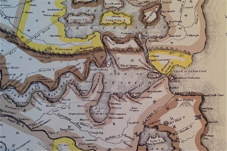
Temperance Map
The nineteenth-century temperance movement in the US sought to curtail alcohol consumption in a nation where it was widespread. Its reach extended to Hawaii, where sailors boozed in port towns and alcohol made its way to the indigenous population. At Lahainaluna Seminary on the island of Maui, Hawaiian students produced this Temperance Map, which depicted the ruinous consequences of alcohol and the rewards of temperance. They also printed a simplified version of the map in Hawaiian. Unlike the ladders, which showed fairly straightforward roads to heaven or hell, the temperance maps offered a tangle of choices that could lead in multiple directions. Viewers were cautioned to exercise constant vigilance. Even if one was happily floating on the Sea of Temperance, making stops at the isles of Longevity and Tranquility, the map showed how easy it was to get swept into Relapse Bay and the Gulf of Broken Pledges. And from there, the Gulf of Perdition was just one wrong turn away.
Credit: by C. Wiltberger Jr. (Published by L. Andrews, Lahainaluna, Maui, Republished in 1972 by the Hale Pa’i Printing Museum of the Lahaina Restoration Foundation, Lahainaluna, Lahaina, Hawaii, 96761). Photograph by author from personal copy. Detail shows the “Sea of Anguish” in the center and the “Sea of Temperance” above it, connected by the “Strait of Total Abstinence” and the “Gulf of Broken Pledges,” which also leads to the “Gulf of Perdition” to the right.
The post The road to hell is mapped with good intentions appeared first on OUPblog.

.png.jpg?picon=4257)
By: Diana Hurwitz,
on 9/6/2013
Blog:
Game On! Creating Character Conflict
(
Login to Add to MyJacketFlap)
JacketFlap tags:
craft,
maps,
scene,
description,
setting,
howto,
tours,
location,
pictures.,
fiction,
writing,
Add a tag
Just as a film director scouts locations for his film, you can scout locations for your book. Whether you are an organic, planner, or hybrid writer, your scenes will be set somewhere.
When you are planning or writing your novel, it helps to have visual images to look at when describing your scenes. You may have chosen a gritty urban streetscape, a desert SciFi terrain, a remote manor house in the Scottish Highlands, or a sheep farm down under. If you are lucky enough to be able to travel to the place and truly absorb the sights, smells, and sounds, you are ahead of the game.
If not, the beautiful thing about the internet age is you don’t have to leave your house to research them. There are travel channels and brochures, DVDs, and movies set in specific locales for you to investigate. It won’t give you the smells, sounds, and tastes, but it is better than making it up entirely in your head.
Thanks to Google Maps and other satellite mapping programs, you can now zoom in and do a 360-degree pan of the area. While it doesn’t allow you to peek inside the windows, you can stroll through a neighborhood in Paris, London, or Peoria for free.
For interior scenes, you can find images through internet search engines. You can find examples of log cabins, Victorian parlors, industrial warehouses, and suburban homes. Tourist sites and real estate sites offer visual tours.
For my current project I needed a Victorian stage and the exterior and interior of a Victorian manor house. Some tours of stately homes offered floor plans. I will create a fictional manor house utilizing the rich details I discovered.
By zooming along England’s coast I found the town of Graves End. Perfect location name for a mystery and close enough to London that my investigators could easily go there by coach. A little more digging and I found it was on the coach line and had people arriving from London several times a day. Of course, Google maps shows a very modern Graves End, but I did find an early map of it as well as illustrations.
Sadly, I cannot afford to go to Graves End and I’d need the Tardis to return to Victorian times. I’ll have to settle for imagining the way it smells and sounds and the way it might have been. But if I hadn’t been scouting for locations, I would never have known it was there.
Inking the last five pages of Maddy right now, which is just over a week's work. I had a small contract this week that caused me to delay finishing it up. Here's Silvio reading his book of cloud maps.

By: Sevensheaven.nl,
on 9/21/2012
Blog:
Sugar Frosted Goodness
(
Login to Add to MyJacketFlap)
JacketFlap tags:
apple,
satire,
cartoon,
metin seven,
sevensheaven,
world,
maps,
Earth,
3d,
ios 6,
clockhouse,
Add a tag
Satire for the Nu.nl news site, about the criticized new Maps application in Apple's iOS 6.
More: sevensheaven.nl
I won't be updating tomorrow due to the holiday, so I thought I'd post my progress thus far. Here is the current iteration of the map I'm working on:
A few more details to finalize/fix and then on to the inking stage.
Tonight I'm getting to design a map for a fantasy series of books. First in black and white for the books themselves, and then there are discussions about a large, colored version for... other applications.
Happy project. I love maps. :-)
By: Zoe,
on 5/30/2012
Blog:
Playing by the book
(
Login to Add to MyJacketFlap)
JacketFlap tags:
Maps,
Treasure,
Boats,
Exploration,
Moving House,
Jonny Duddle,
Crosscultural friendship,
Pirates,
Generosity,
Friendship,
Adventure,
Add a tag
 The Pirates Next Door by Jonny Duddle has been on my to-review pile for a long time. I really rather like the book, but I’ve found it hard to write a review because I can’t help but read it as a satirical story, commenting on society’s attitudes towards “outsiders” (immigrants, travellers, people who are somehow “other”). It’s been difficult for me to find the words to write a book review rather than a political rant.
M (7) would say it’s a extremely funny story about a dream scenario: just how exciting would it be if a real pirate family pitched up to live in our street whilst they repaired their ship? Answer: VERY! And if they left treasure chests behind? …Even better!
My adult head says it’s a rather acutely observed tale about how most people in a neighbourhood react with horror when an strange family arrive in town; there are complaints the pirates don’t wash, they are untidy, they terrorize the people they come into contact with. All in all, most of the pirates’ (grown up) neighbours agree “they won’t fit in round here”.
After a long list of complaints from neighbours, the pirates eventually move on their way, leaving behind wealth and a display of generosity that puts the local residents to shame.

Did Duddle write this book as a commentary on society’s attitudes to “outsiders”? I don’t know. What I do know is that it speaks strongly to me because of my own experience of foreigner nimby-ism: I once had a family of Kurdish refugees as neighbours who enriched my life with generous gifts of lamb dishes perfumed with dill, and stories of humanity against a backdrop of the atrocities committed against their families by Saddam Hussain. They were lovely people. And yet I witnessed them being harassed, abused and threatened by local residents, residents who didn’t even know where they came from (always calling my neighbours Turks – completely incorrectly) but who for some reason felt threatened by this kind, creative family.
But put aside this personal connection, and you’re still left with a great book (indeed, earlier this year it won the Waterstones Children’s Book Prize). Told in rhyme (I want to sing the text, playing my accordion, as if it were a sea shanty that a pirate might very well sing themselves), this is a story for kids of dreams come true. What fun to have naughty neighbours doing everything that you’ve always wanted to do yourself (not having to wash, making people walk the plan, dressing up like a pirate), and how brilliant that in the end they leave you treasure and invite them to sail away with them next holidays.

The illustrations are glossy and remind me of Pixar animations – no doubt these will appeal hugely to kids used to a diet of tv/film/game animation. There are lots of fun details in the pictures (
 There are few illustrated books that offer up so many dreams as atlases.
For me, maps offer possibilities, adventures, intrigue, even if all you ever do with them is enjoy them whilst siting in a comfy armchair at home.
I want to share this dreamland, this interest in exploring, this fascination with the world and the lay of the land with my kids, and so I couldn’t but snap up the opportunity to share the new Barefoot Books World Atlas written by Nick Crane and illustrated by David Dean with M and J.
“An atlas is the most recent chapter of a miracle story.” These are almost the very first words you’ll find inside the cover of the Barefoot Books World Atlas and what an exciting way to introduce this rich, lavishly illustrated and thought-provoking journey around the world. Indeed the opening spread is a story of a beginning; how the earth came into being, what the first signs of life were and the evolution of the human species. Along with a section on map-making and map-projections, the opening brief history of the world is a brilliant bit of scene-setting, context-giving drama that also way-marks the direction the atlas takes throughout: a scientific exploration looking at how humans have reacted to, utilised and exploited the landscapes around them.
Nick Crane lays plain the politics that have always been inherent in map making:
The way in which people design atlases is influenced by many factors, including the knowledge they have about the physical features and distances within the different regions; what aspects of life are culturally, economically and politically significant to them; and what geometric techniques they have mastered.
He then goes on to acknowledge what his atlas will focus on:
Until recently, human beings have lived on the planet in a relatively sustainable way. seldom taking more than can be replaced by natural growth. But in the past century, this balance has changed [...] We are living at the start of a new chapter in the story of our planet and its central theme is the way in which we work together as a global community to protect it.
The first map in the Barefoot Books World Atlas introduces the 7 continents and 5 oceans. With this as a starting point the next selection of maps all focus on the oceans – perhaps an unusual, albeit excellent, decision, given that oceans actually cover the vast majority of the globe.

Each map is accompanied by a page or so of comments, often with flaps or fold-outs adding to the fun. Included in each set of notes are summaries of the local climate, physical features, land use and natural resources, and peoples and notable places. The maps are vibrantly coloured and full of small images depicting key cultural artefacts, animals, transport networks, national costumes and buildings amongst others. In this respect the Barefoot Books World Atlas reminded me of
3 Comments on Exploring the world with kids, last added: 1/11/2012
 Do you know anyone who’s expecting a baby soon? If the answer is yes, then forego another babygro and give the new baby a book – baby and parents will get much more enjoyment out of the gift, and it may even stay with them their whole life
But what book to give?
Peepo! and The Baby’s Catalogue, or an Eric Carle book are all popular choices, but me? The next baby I’ll be giving a book to is going to receive the new Taro Gomi Board Book Boxed Set which is made up chunky versions of Spring is Here, My Friends and Bus Stops.
Spring is Here tours the four seasons but what makes it different from many other books about the seasonal change is that the story appears to take place on the back of a young calf! This may sounds strange, but it’s actually an effective way of showing that the change from spring to summer and so on is not just as a cycle abstractly repeating itself but also physical time moving forward. As the seasons change the calf (and by extension the reader) grow up and older.
My Friends is a playful appreciation of friends in all forms and what we learn from different sources of inspiration. The text is like a beautiful poem, for example:
I learned to watch the night sky from my friend the owl.
I learned to sing from my friends the birds.
I learned to read from my friends the books.
And the final lines of this poem are the loveliest I’ve read in a long time in the often-too-saccharinny world of love-makes-the-world-go-round type children’s books. This little book brings a tear to my eye and makes me (even after repeated readings) hug which ever child I’m reading to.

J reading My Fr


I found this an interesting read as the book in my current blogpost, Imani’s Moon’, is set in Africa. Reading this story has given us a glimpse into a completely different country and culture which is not only fascinating for my daughter but for me as well. We also love the Anna Hibiscus books, the fact that they are set in a country that we aren’t familiar with enriches and extends our knowledge and reading experience.
We love the Katie Morag books and I agree with you that regardless of the setting they introduce experiences that are familiar to many children and have a strong emphasis on family life. This looks like a beautiful treasury for a Christmas present
Catherine – yes it would make a very special Christmas present
Oh we love and adore Katie Morag… Love… all the way from sunny South Africa. I think we relate to it so well because we also live in a seaside town… so there is lots in common. But a big part of Katie’s appeal is that she does live on a far side of the world in a distant and remote place, everything is so very different. So much the same, we have very similar grannies (!!!) and yet so much is different – my kids have never worn gumboots… and Katie almost always does. I could write all day, we love and adore Katie and hope this collection comes to a publisher near us really soon!!!
Katie Morag is a huge favourite in our house!
Somehow makes me think of Baaalaaamoreeee..!