


Antebellum Americans were enamored of maps. In addition to mapping the United States’ land hunger, they also plotted weather patterns, epidemics, the spread of slavery, and events from the nation’s past.
And the afterlife.
Imaginative maps to heaven and hell form a peculiar subset of antebellum cartography, as Americans surveyed not only the things they could see but also the things unseen. Inspired by the biblical injunction to “Enter ye in at the strait gate: for wide is the gate, and broad is the way, that leadeth to destruction… and narrow is the way, which leadeth unto life, and few there be that find it” (Matthew 7:13-14 KJV), the maps provided striking graphics connecting beliefs and behavior in this life to the next.
-
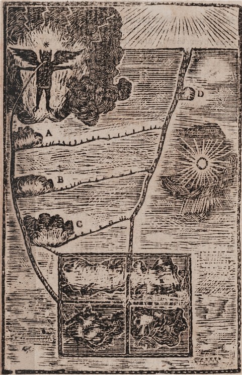
“Mah-tan’-tooh, or the Devil, standing in a flame of fire, with open arms to receive the wicked.”
As early as the 17th century, Catholic missionaries were using didactic visuals of heaven and hell to surmount a language barrier with indigenous North Americans. Such illustrations probably influenced the cosmological map of Neolin, the Delaware Prophet. Born around 1762 near Lake Erie, Neolin experienced a series of otherworldly visions that he turned into a map for his followers. The image here, copied by a white observer, was published some years later in a volume of captivity narratives. The rectangle at the bottom of the map represented the earth and its inhabitants. Those who avoided temptation would proceed directly to future bliss on the path labeled “D,” while those who followed paths A, B, and C would undergo various purgation processes before receiving their reward. The wicked, on the bottom left of the rectangle, would go straight to a fiery hell guarded by the Devil. Neolin warned his followers that the vices Europeans brought, like alcohol consumption, had made the path to future bliss more perilous.
Credit: In Archibald Loudon, A selection, of some of the most interesting narratives, of outrages, committed by the Indians, in their wars, with the white people… (Carlisle [Pa.]: From the press of A. Loudon (Whitehall), 1808-1811). Monroe Wakeman and Holman Loan Collection of the Pequot Library Association, on deposit in the Beinecke Rare Book and Manuscript Library, Pequot L92. Courtesy of the Beinecke Rare Book and Manuscript Library.
-
Catholic Ladder
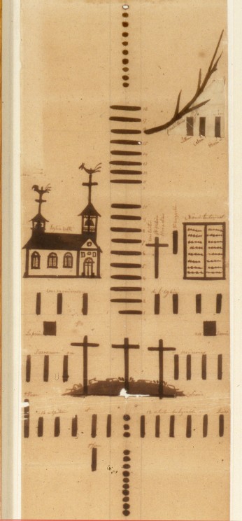
Like earlier didactic devices, this Catholic Ladder (ca. 1840) was created by a French Catholic missionary for the purpose of evangelization. First carved into a large wooden stick, and then painted on a paper scroll measuring nearly five feet long, the Catholic Ladder served as a visual aid for Father Francis Norbert Blanchet and his associates to explain sacred history to the indigenous people of the Pacific Northwest. Blanchet drew bars to represent the passage of centuries and dots to represent years in the life of Christ, and added simple pictures to illustrate sacred events. There is no sign of heaven or hell in this ladder, which simply ends with Blanchet’s mission in the present day. But this wasn’t just a neutral timeline: for Blanchet, there clearly is a wrong path to follow. In the detail shown here, Blanchet depicted the Protestant Reformation as a spindly branch off the main course of sacred history, with the three bars below it representing Luther, Calvin, and Henry VIII.
Credit: By Fr. Francis Norbert Blanchet, ca. 1840. 6 1/2 x 58 in. Section from middle of ladder, showing the Crucifixion to the Protestant Reformation. Courtesy of The Oregon Historical Society, Image Number OrHi 89315.
-
Protestant Ladder
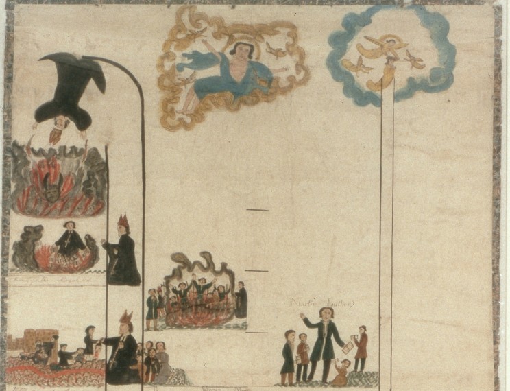
Protestant missionaries Henry and Eliza Spalding, who also traveled to the Pacific Northwest, responded to the Catholic depiction of Reformation heroes with a ladder of their own. Six feet long and two feet wide, the ladder made explicit the biblical teaching about the wide and narrow paths. Painted by Eliza with ink and colored dyes made from berries and natural pigments, the ladder, like Blanchet’s, also illustrated sacred history beginning with Adam and Eve. But it divided this history into the good and the bad, and instead of ending in the present, it ended with the reward of the righteous and the punishment of the wicked. On the right (directionally and morally) path to heaven, the Spaldings included Moses, Paul, and Martin Luther. On the left and wider path to hell, they featured the Tower of Babel, the beheading of John the Baptist, and several scenes with the Pope, culminating with his headfirst fall into a fiery hell where a horned devil awaits.
Credit: By Henry H. and Eliza Spalding, ca. 1845. Section from top of ladder. Courtesy of The Oregon Historical Society, Image Number OrHi 87847.
-
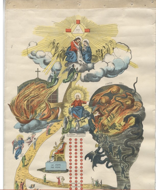
Tableau-catéchisme/Pictorial catechism
If the colorful and dramatic Protestant Ladder was more visually exciting than Blanchet’s monochrome series of bars and dots, Albert Lacombe’s mass-produced version from the 1870s was even more so. Lithography techniques had improved by this time, making it possible to make tens of thousands of copies of the striking six foot by one foot scroll. Like the Spaldings, Lacombe embellished the idea of the two roads to heaven and hell, but his was a Catholic version that included a fiery Purgatory on the path to heaven. And, where the Spaldings had the Pope falling into the flames of hell, Lacombe featured the richly-clad Pope on a gilded throne, pointing the way to heaven. No surprise that the Pope himself endorsed the ladder, which saw use among Catholic missionaries worldwide.
Credit: By Reverend Albert Lacombe, O.M.I., 1874. Purgatory to the left, hell to the right, heaven above. Original at Missionary Oblates, Grandin Province Archives at the Provincial Archives of Alberta. Printed on four pasted panels glued together and backed with linen, attached to a stick, and rolled like a scroll. Electronic image courtesy of the Department of Special Collections and University Archives, Marquette University Libraries.
-
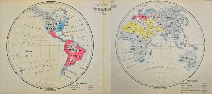
Frontispiece in John Cameron Lowrie, A Manual of Missions, or, Sketches of the Foreign Missions of the Presbyterian Church
On the face of it, this is not a guide to heaven or hell. It is a detailed map of the world, so rooted in the here-and-now that it is meticulously plotted along latitude and longitude. It seems fairly neutral at first glance. But the color-coded key tells a more partisan story. Each region of the world is colored according to religion. For John Cameron Lowrie, the corresponding secretary of the Presbyterian Board of Foreign Missions, only the blue of Protestantism was salvific. The didactic moral of the map? Live in or move to a blue zone, and help to color the rest of the world blue by converting its inhabitants to Protestantism and hence saving them from eternal damnation.
Credit: Photograph by Nicholas Lum.
-
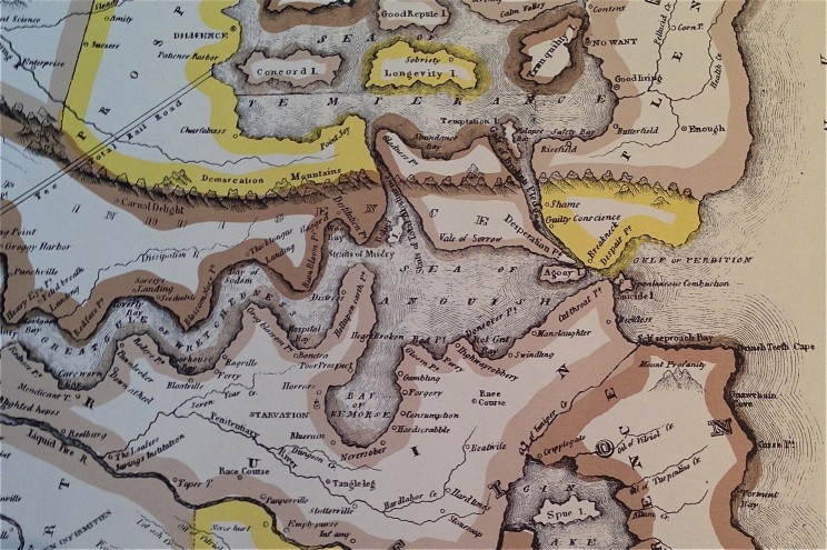
Temperance Map
The nineteenth-century temperance movement in the US sought to curtail alcohol consumption in a nation where it was widespread. Its reach extended to Hawaii, where sailors boozed in port towns and alcohol made its way to the indigenous population. At Lahainaluna Seminary on the island of Maui, Hawaiian students produced this Temperance Map, which depicted the ruinous consequences of alcohol and the rewards of temperance. They also printed a simplified version of the map in Hawaiian. Unlike the ladders, which showed fairly straightforward roads to heaven or hell, the temperance maps offered a tangle of choices that could lead in multiple directions. Viewers were cautioned to exercise constant vigilance. Even if one was happily floating on the Sea of Temperance, making stops at the isles of Longevity and Tranquility, the map showed how easy it was to get swept into Relapse Bay and the Gulf of Broken Pledges. And from there, the Gulf of Perdition was just one wrong turn away.
Credit: by C. Wiltberger Jr. (Published by L. Andrews, Lahainaluna, Maui, Republished in 1972 by the Hale Pa’i Printing Museum of the Lahaina Restoration Foundation, Lahainaluna, Lahaina, Hawaii, 96761). Photograph by author from personal copy. Detail shows the “Sea of Anguish” in the center and the “Sea of Temperance” above it, connected by the “Strait of Total Abstinence” and the “Gulf of Broken Pledges,” which also leads to the “Gulf of Perdition” to the right.
The post The road to hell is mapped with good intentions appeared first on OUPblog.


These are amazing! I love traveling and finding the modern version for cities and towns~ I know they're tourist gimmicks for the most part, but I still like looking at them. I remember loving the "picture maps" when we took family trips, because I could see drawings of the shops, mountains, beaches, restaurants, attractions. It was very cool for someone who had just been reading for a few years to be able to say, "Hey Dad! Go up two streets and to the left! The beach is right over there." Same thing for maps of Disney World and the like. I could stare at those for hours. This goatskin map, of course, is an even bigger marvel :)
Yes! I too, loved those picture maps. Still do. I hadn't really thought of them as being our modern version of these old 'story telling' maps, though.