new posts in all blogs
Viewing: Blog Posts Tagged with: keene, Most Recent at Top [Help]
Results 1 - 6 of 6
How to use this Page
You are viewing the most recent posts tagged with the words: keene in the JacketFlap blog reader. What is a tag? Think of a tag as a keyword or category label. Tags can both help you find posts on JacketFlap.com as well as provide an easy way for you to "remember" and classify posts for later recall. Try adding a tag yourself by clicking "Add a tag" below a post's header. Scroll down through the list of Recent Posts in the left column and click on a post title that sounds interesting. You can view all posts from a specific blog by clicking the Blog name in the right column, or you can click a 'More Posts from this Blog' link in any individual post.

By: Rebecca,
on 9/23/2008
Blog:
OUPblog
(
Login to Add to MyJacketFlap)
JacketFlap tags:
Keene,
Ben,
Add a tag

Having just returned from eight days in England, I was slightly at a loss about what to feature in my weekly post this afternoon. But an item in today’s news caught my attention and got me thinking about geography. According to the 2008 Farm Bill that the U.S. Congress just passed this summer, all unprocessed meat, produce, as well as selected nuts will have to be labeled with their country of origin beginning next Tuesday, September 30. Touted as a safety measure to help American consumers make informed decisions about their food purchases, I wonder if it will do anything to improve our geographic literacy. Are we just a nation of shoppers looking for a bargain and familiar brands, or are we prepared to educate ourselves about how and where the things we eat are raised, grown, fertilized, or slaughtered? Although symbols and flags have not been deemed permissible labels (personally, I think small silhouettes of each country would be truly—pun intended—COOL), I’m of the belief that such abbreviations might actually force us to learn even more than we will from the names of countries alone. Just think of all the moms and dads pushing their inquisitive children around grocery stores in Maine or California. What questions might they ask upon spotting a piece of fruit bearing the image of Chile’s long, sinuous outline, or a package of peanuts stickered with the vaguely Pac-Man-esque shape of Senegal?
Learn more here and here.

Ben Keene is the editor of
Oxford Atlas of the World. Check out some of his
previous places of the week.
ShareThis
By: Rebecca,
on 6/3/2008
Blog:
OUPblog
(
Login to Add to MyJacketFlap)
JacketFlap tags:
editor,
oxford,
Geography,
A-Featured,
keene,
Ben's Place of the Week,
atlas,
week,
ben keene,
places,
previous,
check,
Add a tag
Ben Keene is the editor of Oxford Atlas of the World. Check out some of his previous places of the week.
Arizona Strip
Coordinates: 36 50 N 113 0 W
Approximate area: 7,878 sq mi (20,404 sq km)
Last week I made my first visit to the Beehive State, or Utah as most of us know it, for some hiking, camping, and a bit of exploration via hybrid car. On Sunday, as I headed back to the airport, I decided to take a short detour to a region that the Bureau of Land Management includes “among the most remote and rugged public land in the lower 48 states.” Just over Arizona’s northern border, this two million acre swathe of sandstone mesas and ponderosa forest was covered in enough lush grass around the turn of the last century to support tens of thousands of cattle. Extensive logging and overgrazing reduced much of the land to desert scrub so while ranching persists here on the Arizona Strip, the number of animals isn’t nearly what it used to be. In fact, as I drove through the Kaibab Paiute Indian Reservation east of Fredonia, I saw little evidence of the human history that has unfolded here save for telephone poles, barbed wire fences, and rarely, a modest house.
ShareThis
By: Rebecca,
on 4/15/2008
Blog:
OUPblog
(
Login to Add to MyJacketFlap)
JacketFlap tags:
Food and Drink,
Geography,
A-Featured,
maps,
keene,
ben,
mango,
Ben's Place of the Week,
atlas,
ben keene,
burma,
chin hills,
chin,
hills,
taxman,
mangos,
cashew,
pinpointing,
Add a tag

Chin Hills, Burma
Coordinates: 22 30 N 93 30 E
Maximum elevation: 10,018 feet (3,053 m)
Desperately trying to keep the Taxman at bay for a few more hours, I wound up at my favorite Monday night watering hole with a few friends last night, earnestly discussing the summer foods we enjoyed most. After listening to everyone’s peculiar arguments I found myself championing the mango as the perfect fruit for warmer days ahead. And yet as I tried to explain its versatility as an ingredient and its unrivaled popularity (the National Mango Board claims that more fresh mangos are eaten every day than any other fruit in the world), I realized that I knew precious little about its geographical origins.
As it turns out, this succulent relative of the cashew and the pistachio has been consumed in India for thousands of years, although it didn’t reach the United States until the late nineteenth century. Pinpointing the location of the first mango, when there are hundreds of varieties of the plant today, is not something I wanted to undertake but fortunately others had already agreed on the higher terrain forming the border between India and Burma (Myanmar). Running north-south, the evergreen-clad Chin Hills stretch across much of this tropical zone, and may hide an ancient progenitor in their forested slopes.

Ben Keene is the editor of
Oxford Atlas of the World. Check out some of his
previous places of the week.
ShareThis
By: Rebecca,
on 3/11/2008
Blog:
OUPblog
(
Login to Add to MyJacketFlap)
JacketFlap tags:
Film,
Geography,
A-Featured,
maps,
belgium,
keene,
ben,
Ben's Place of the Week,
bruges,
hitman,
caper,
hanseatic,
cobblestone,
zywn,
grit,
atlas,
Add a tag
Bruges, Belgium
Coordinates: 51 13 N 3 13 E
Population: 117,025 (2004 est.)
Earlier this month a new crime caper opened in theaters across the country with a rather unusual setting. Instead of a menacing metropolis teeming with villains and oozing with urban grit and gloom, director Martin McDonagh chose to shoot his film in the medieval Belgian city that appears in the title: Bruges. (more…)
Share This
I'm happy to be participating in the Keene college owl project. In conjunction with Keene's children's literature festival the college is asking children's illustrators to donate an illustration of an owl (the school's mascot) to their wonderful collection of original children's book art. And since Keene not too far from where I live and my old high school mascot was also an owl I was happy to contribute.
I started out with an owl on a branch.
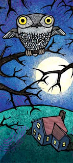
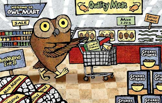
I thought it turned out all right, but I figured Keene had plenty of owls sitting on tree branches. So I tried to think of something that might be a little more unusual. Something you don't usually see owls doing. Like, I don't know, shopping for moth-mallows at the local Owl-Mart.
By: Ben Zimmer,
on 7/5/2007
Blog:
OUPblog
(
Login to Add to MyJacketFlap)
JacketFlap tags:
oxford,
language,
A-Featured,
Lexicography,
dictionary,
Dictionaries,
spelling,
english,
zimmer,
From A To Zimmer,
miniscule,
minuscule,
diminution,
nonstandard,
usage,
Add a tag

Last week for my inaugural column here at OUPblog I talked about how new words bubble up into the English lexicon and how Oxford lexicographers judge which ones deserve inclusion in new editions of our dictionaries. But we’re keeping tabs on many other more subtle aspects of our changing language beyond the flashy lexical newcomers. Take spelling errors, for instance. Dictionaries are, of course, expected to give the standard spellings of words and phrases, reflecting what is generally considered the most correct and acceptable in written English. But sometimes common misspellings tell us fascinating things about how writers navigate the tricky waters of English orthography. And sometimes once-nonstandard spellings become so widely accepted that they even (gasp) make it into the pages of the dictionary. (more…)
Share This


A lot of canned tuna is from the Seychelles; that would be hard to recognize!
[…] the original post: The Geography of Food You can follow any responses to this entry through the RSS 2.0 feed. You can leave a response, […]
Not only would the Seychelles be hard to recognize in silhouette, they would be hard to print on a can of tuna!